Sorry the change what you did write nothing change at mt visu.
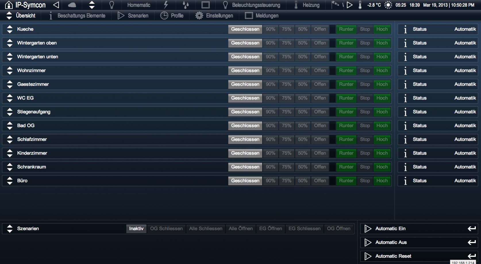
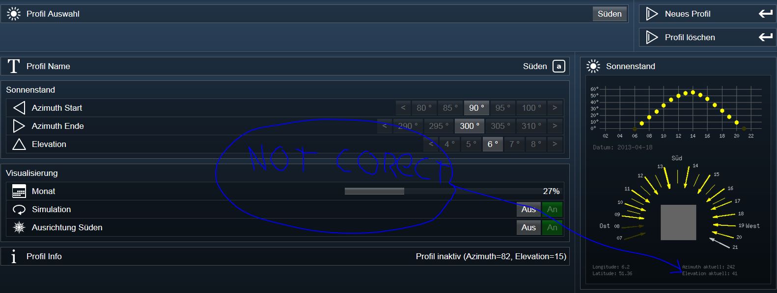
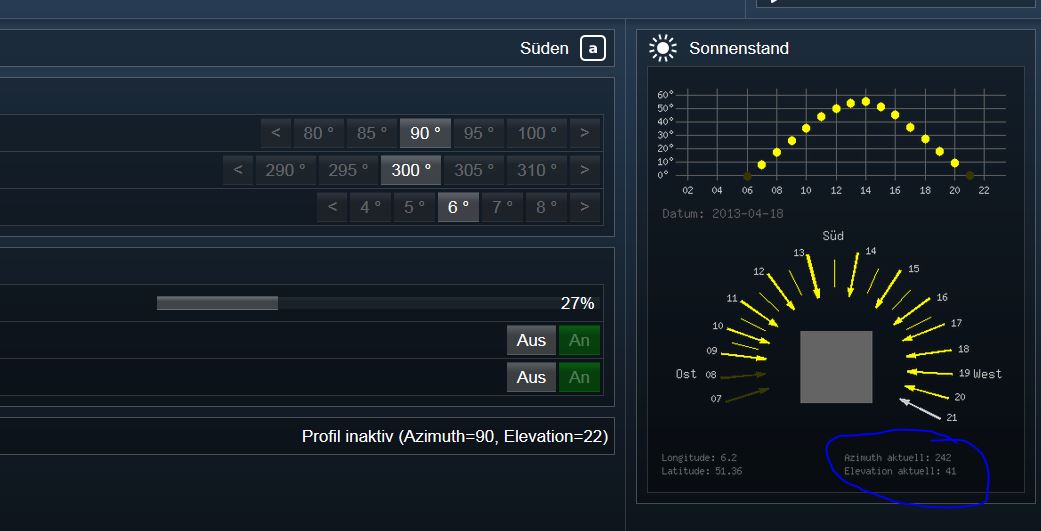
The problem is also that the shadowing going down in the morning by „tagesbegin“ also when the sun is not strong!!
i think i do something wrong in my settings also but i don’t can find it.
I hope there is someone what can help me a littel.
Thanks, Ron
<?
/*
* This file is part of the IPSLibrary.
*
* The IPSLibrary is free software: you can redistribute it and/or modify
* it under the terms of the GNU General Public License as published
* by the Free Software Foundation, either version 3 of the License, or
* (at your option) any later version.
*
* The IPSLibrary is distributed in the hope that it will be useful,
* but WITHOUT ANY WARRANTY; without even the implied warranty of
* MERCHANTABILITY or FITNESS FOR A PARTICULAR PURPOSE. See the
* GNU General Public License for more details.
*
* You should have received a copy of the GNU General Public License
* along with the IPSLibrary. If not, see http://www.gnu.org/licenses/gpl.txt.
*/
/**@addtogroup ipsshadowing
* @{
*
* @file IPSShadowing_Azimuth.inc.php
* @author Andreas Brauneis
* @version
* Version 2.50.1, 21.03.2012<br/>
*
* Berechnung/Grafik von Azimuth und Elevation
*
*/
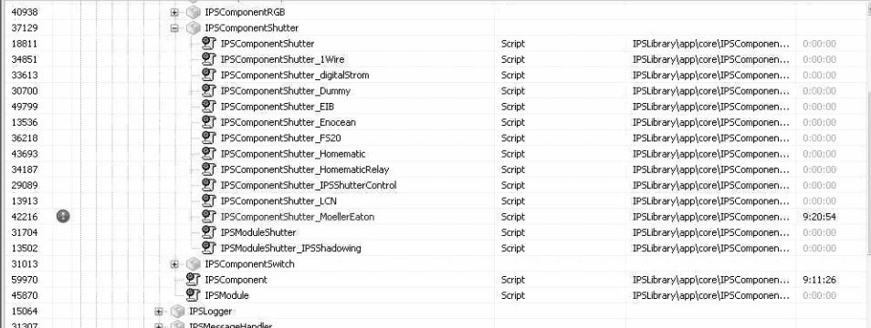
IPSUtils_Include ("IPSLogger.inc.php", "IPSLibrary::app::core::IPSLogger");
IPSUtils_Include ("IPSComponent.class.php", "IPSLibrary::app::core::IPSComponent");
IPSUtils_Include ("IPSShadowing_Constants.inc.php", "IPSLibrary::app::modules::IPSShadowing");
IPSUtils_Include ("IPSShadowing_Configuration.inc.php", "IPSLibrary::config::modules::IPSShadowing");
IPSUtils_Include ("IPSShadowing_Custom.inc.php", "IPSLibrary::config::modules::IPSShadowing");
IPSUtils_Include ("IPSShadowing_Logging.inc.php", "IPSLibrary::app::modules::IPSShadowing");
IPSUtils_Include ("IPSShadowing_Device.class.php", "IPSLibrary::app::modules::IPSShadowing");
IPSUtils_Include ("IPSShadowing_ProfileTemp.class.php", "IPSLibrary::app::modules::IPSShadowing");
IPSUtils_Include ("IPSShadowing_ProfileTime.class.php", "IPSLibrary::app::modules::IPSShadowing");
IPSUtils_Include ("IPSShadowing_ProfileManager.class.php", "IPSLibrary::app::modules::IPSShadowing");
IPSUtils_Include ("IPSShadowing_Scenario.class.php", "IPSLibrary::app::modules::IPSShadowing");
IPSUtils_Include ("IPSShadowing_ScenarioManager.class.php", "IPSLibrary::app::modules::IPSShadowing");
//IPSShadowing_GenerateSunGraphic(time(), 150, 190,30);
function IPSShadowing_GenerateSunGraphic($graphDate, $azimuthBgn=110, $azimuthEnd=220, $elevationLvl=20, $orientationSouth=false) {
$longitude = IPSSHADOWING_LONGITUDE;
$latitude = IPSSHADOWING_LATITUDE;
$orientationDeg = IPSSHADOWING_BUILDINGORIENTATION;
$relationDeg = IPSSHADOWING_BUILDINGRELATION;
$imageWidth = 400;
$imageHeight = 450;
$image = imagecreate($imageWidth,$imageHeight);
$white = imagecolorallocate($image,255,255,255);
$textColor = imagecolorallocate($image,250,250,250);
$transparent = imagecolortransparent($image,$white);
$elevationVOffset = 110;
$elevationSunRadio = 10;
$elevationFactor = 1.5;
$elevationColorAct = imagecolorallocate($image, 255, 255, 0); // Yellow
$elevationColorNor = imagecolorallocate($image, 55, 55, 0);
$elevationColorLine = imagecolorallocate($image, 100, 100, 100);
$elevationColorText = imagecolorallocate($image, 200, 200, 200);
$sunDegree = $orientationSouth ? 0 : $orientationDeg;
$sunOffsetH = $imageWidth/2;
$sunOffsetV = $imageHeight/2+100;
$sunRadius1 = $imageWidth/2-70;
$sunRadius2 = $imageWidth/5;
$sunColorAct = imagecolorallocate($image, 255, 255, 0); // Yellow
$sunColorEle = imagecolorallocate($image, 200, 200, 200);
$sunColorNor = imagecolorallocate($image, 55, 55, 0);
$buildingDeg1 = $orientationSouth ? 45 - $orientationDeg : 45;
$buildingDeg2 = $relationDeg;
$buildingVOffset= $sunOffsetV;
$buildingHOffset= $imageWidth/2;
$buildingRadius = $imageWidth/7;
$buildingColor = imagecolorallocate($image, 100, 100, 100); // Grey
// Prepare Elevation Display
for ($idx=0;$idx<=60;$idx=$idx+10) {
imageline($image, 20, $elevationVOffset-$idx*$elevationFactor, $imageWidth-10, $elevationVOffset-$idx*$elevationFactor, $elevationColorLine);
imagestring($image,2,0,$elevationVOffset-$idx*$elevationFactor-7,$idx."°",$elevationColorText);
}
for ($hour=2;$hour<=22;$hour=$hour+2) {
imageline($image, $imageWidth/24*$hour, $elevationVOffset+5, $imageWidth/24*$hour, $elevationVOffset-60*$elevationFactor-7, $elevationColorLine);
imagestring($image,2,$imageWidth/24*$hour-5,$elevationVOffset+10,str_pad($hour, 2, "0", STR_PAD_LEFT),$elevationColorText);
}
for ($hour=0; $hour<24; $hour++) {
$data = Get_AnzimuatAndElevation(mktime($hour, 0, 0, date('n',$graphDate), date('d', $graphDate), date("Y",$graphDate)), $longitude, $latitude);
$azimuth = round($data['Azimuth']);
$elevation = round($data['Elevation']);
// Elevation
// --------------------------------------------------------------------------------------------------------------------------
if ($elevation >= -5) {
$elevationColor = $elevationColorNor;
if ($elevation>=$elevationLvl) {$elevationColor = $elevationColorAct;}
imagefilledarc($image, $imageWidth/24*$hour, $elevationVOffset-$elevation*$elevationFactor, $elevationSunRadio, $elevationSunRadio, 0, 360, $elevationColor, IMG_ARC_PIE);
}
// Print Sun
$sunColor = $sunColorNor;
if ($azimuth>=$azimuthBgn and $azimuth<=$azimuthEnd) {
$sunColor = $sunColorAct;
if ($elevation < $elevationLvl) $sunColor = $sunColorEle;
}
// Azimut
// --------------------------------------------------------------------------------------------------------------------------
if ($elevation >=0) {
$deg = 270-$azimuth-$sunDegree;
$x1 = round(cos(($deg) * M_PI / 180) * $sunRadius1)+$sunOffsetH;
$y1 = round(sin(($deg) * M_PI / 180) * $sunRadius1);
$x2 = round(cos(($deg+1) * M_PI / 180) * $sunRadius1)+$sunOffsetH;
$y2 = round(sin(($deg+1) * M_PI / 180) * $sunRadius1);
$x3 = round(cos(($deg+1) * M_PI / 180) * $sunRadius2)+$sunOffsetH;
$y3 = round(sin(($deg+1) * M_PI / 180) * $sunRadius2);
$x4 = round(cos(($deg) * M_PI / 180) * $sunRadius2)+$sunOffsetH;
$y4 = round(sin(($deg) * M_PI / 180) * $sunRadius2);
$x5 = round(cos(($deg-1.5) * M_PI / 180) * ($sunRadius2+10))+$sunOffsetH;
$y5 = round(sin(($deg-1.5) * M_PI / 180) * ($sunRadius2+10));
$x6 = round(cos(($deg+2.5) * M_PI / 180) * ($sunRadius2+10))+$sunOffsetH;
$y6 = round(sin(($deg+2.5) * M_PI / 180) * ($sunRadius2+10));
imagefilledpolygon ($image ,array($x1,$sunOffsetV-$y1,$x2,$sunOffsetV-$y2,$x3,$sunOffsetV-$y3,$x4,$sunOffsetV-$y4), 4, $sunColor);
imagefilledpolygon ($image ,array($x3,$sunOffsetV-$y3,$x4,$sunOffsetV-$y4,$x5,$sunOffsetV-$y5,$x6,$sunOffsetV-$y6), 4, $sunColor);
$x3 = round(cos($deg * M_PI / 180) * $sunRadius1+9)+$sunOffsetH;
$y3 = round(sin($deg * M_PI / 180) * $sunRadius1+9);
if ($x3<=$imageWidth/2) {$x3=$x3-25;}
imagestring($image,2,$x3,$sunOffsetV-$y3,str_pad($hour, 2, "0", STR_PAD_LEFT),$elevationColorText);
}
}
for ($hour=9; $hour<17; $hour++) {
$data = Get_AnzimuatAndElevation(mktime($hour, 30, 0, date('n',$graphDate), date('d', $graphDate), date("Y",$graphDate)), $longitude, $latitude);
$azimuth = round($data['Azimuth']);
$elevation = round($data['Elevation']);
$sunColor = $sunColorNor;
if ($azimuth>=$azimuthBgn and $azimuth<=$azimuthEnd) {
$sunColor = $sunColorAct;
if ($elevation < $elevationLvl) $sunColor = $sunColorEle;
}
if ($elevation >=10) {
$deg = 270-$azimuth-$sunDegree;
$x1 = round(cos(($deg) * M_PI / 180) * ($sunRadius1-10))+$sunOffsetH;
$y1 = round(sin(($deg) * M_PI / 180) * ($sunRadius1-10));
$x2 = round(cos(($deg) * M_PI / 180) * ($sunRadius1-10))+$sunOffsetH;
$y2 = round(sin(($deg) * M_PI / 180) * ($sunRadius1-10));
$x3 = round(cos(($deg) * M_PI / 180) * ($sunRadius2+10))+$sunOffsetH;
$y3 = round(sin(($deg) * M_PI / 180) * ($sunRadius2+10));
$x4 = round(cos(($deg) * M_PI / 180) * ($sunRadius2+10))+$sunOffsetH;
$y4 = round(sin(($deg) * M_PI / 180) * ($sunRadius2+10));
imageline($image, $x1,$sunOffsetV-$y1, $x3,$sunOffsetV-$y3, $sunColor);
}
}
$x3 = round(cos((270-90-$sunDegree) * M_PI / 180) * ($sunRadius1+50))+$sunOffsetH;
$y3 = round(sin((270-90-$sunDegree) * M_PI / 180) * ($sunRadius1+50));
imagestring($image,4,$x3,$sunOffsetV-$y3,'Ost',$elevationColorText);
$x3 = round(cos((270-180-$sunDegree) * M_PI / 180) * ($sunRadius1+25))+$sunOffsetH-15;
$y3 = round(sin((270-180-$sunDegree) * M_PI / 180) * ($sunRadius1+25));
imagestring($image,4,$x3,$sunOffsetV-$y3,'Süd',$elevationColorText);
$x3 = round(cos((270-270-$sunDegree) * M_PI / 180) * ($sunRadius1+25))+$sunOffsetH;
$y3 = round(sin((270-270-$sunDegree) * M_PI / 180) * ($sunRadius1+25));
imagestring($image,4,$x3,$sunOffsetV-$y3,'West',$elevationColorText);
 		$data  = Get_AnzimuatAndElevation( time(), $longitude, $latitude);
    $azimuth   = round($data['Azimuth']);
    $elevation = round($data['Elevation']);

 		// Print Building
		// --------------------------------------------------------------------------------------------------------------------------
$points = array(
round(cos(($buildingDeg1-$buildingDeg2) * M_PI / 180) * $buildingRadius)+$buildingHOffset,
round(sin(($buildingDeg1-$buildingDeg2) * M_PI / 180) * $buildingRadius)+$buildingVOffset,
round(cos(($buildingDeg1+90+$buildingDeg2) * M_PI / 180) * $buildingRadius)+$buildingHOffset,
round(sin(($buildingDeg1+90+$buildingDeg2) * M_PI / 180) * $buildingRadius)+$buildingVOffset,
round(cos(($buildingDeg1+180-$buildingDeg2) * M_PI / 180) * $buildingRadius)+$buildingHOffset,
round(sin(($buildingDeg1+180-$buildingDeg2) * M_PI / 180) * $buildingRadius)+$buildingVOffset,
round(cos(($buildingDeg1+270+$buildingDeg2) * M_PI / 180) * $buildingRadius)+$buildingHOffset,
round(sin(($buildingDeg1+270+$buildingDeg2) * M_PI / 180) * $buildingRadius)+$buildingVOffset ,
);
imagefilledpolygon ($image ,$points, 4, $buildingColor);
imagestring($image,4,5,$elevationVOffset+35, 'Datum: '.date('Y-m-d',$graphDate),$buildingColor);
imagestring($image,2,5,$imageHeight-15, 'Latitude: '.round($latitude,2),$buildingColor);
imagestring($image,2,5,$imageHeight-30, 'Longitude: '.round($longitude,2),$buildingColor);
imagestring($image,2,$imageWidth/2+10,$imageHeight-15, 'Elevation aktuell: '.$elevation,$buildingColor);
imagestring($image,2,$imageWidth/2+10,$imageHeight-30, 'Azimuth aktuell: '.$azimuth,$buildingColor);
// Write File
imagegif ($image, IPS_GetKernelDir().'media\\IPSShadowing_Azimuth.gif', 90);
imagedestroy($image);
}
function IPSShadowing_GenerateSunGraphicOld($graphDate, $azimuthBgn=110, $azimuthEnd=220, $elevationLvl=20) {
$longitude = IPSSHADOWING_LONGITUDE;
$latitude = IPSSHADOWING_LATITUDE;
$imageWidth = 300;
$imageHeight = 400;
$image = imagecreate($imageWidth,$imageHeight);
$white = imagecolorallocate($image,255,255,255);
$textColor = imagecolorallocate($image,250,250,250);
$transparent = imagecolortransparent($image,$white);
$elevationVOffset = 110;
$elevationSunRadio = 10;
$elevationFactor = 1.5;
$elevationColorAct = imagecolorallocate($image, 255, 255, 0); // Yellow
$elevationColorNor = imagecolorallocate($image, 55, 55, 0);
$elevationColorLine = imagecolorallocate($image, 100, 100, 100);
$elevationColorText = imagecolorallocate($image, 200, 200, 200);
$sunOffsetH = $imageWidth/2;
$sunOffsetV = $imageHeight/2+80;
$sunRadius1 = $imageWidth/2-20;
$sunRadius2 = $imageWidth/4;
$sunColorAct = imagecolorallocate($image, 255, 255, 0); // Yellow
$sunColorEle = imagecolorallocate($image, 200, 200, 200);
$sunColorNor = imagecolorallocate($image, 55, 55, 0);
$buildingDeg1=15;
$buildingDeg2=20;
$buildingVOffset=$sunOffsetV;
$buildingHOffset=$imageWidth/2;
$buildingRadius=$imageWidth/5;
$buildingColor = imagecolorallocate($image, 100, 100, 100); // Grey
// Prepare Elevation Display
for ($idx=0;$idx<=60;$idx=$idx+10) {
imageline($image, 20, $elevationVOffset-$idx*$elevationFactor, $imageWidth-10, $elevationVOffset-$idx*$elevationFactor, $elevationColorLine);
imagestring($image,2,0,$elevationVOffset-$idx*$elevationFactor-7,$idx."°",$elevationColorText);
}
for ($hour=2;$hour<=22;$hour=$hour+2) {
imageline($image, $imageWidth/24*$hour, $elevationVOffset+5, $imageWidth/24*$hour, $elevationVOffset-60*$elevationFactor-7, $elevationColorLine);
imagestring($image,2,$imageWidth/24*$hour-5,$elevationVOffset+10,str_pad($hour, 2, "0", STR_PAD_LEFT),$elevationColorText);
}
for ($hour=0; $hour<24; $hour++) {
$data = Get_AnzimuatAndElevation(mktime($hour, 0, 0, date('n',$graphDate), date('d', $graphDate), date("Y",$graphDate)), $longitude, $latitude);
$azimuth = round($data['Azimuth']);
$elevation = round($data['Elevation']);
// Elevation
// --------------------------------------------------------------------------------------------------------------------------
if ($elevation >= -5) {
$elevationColor = $elevationColorNor;
if ($elevation>=$elevationLvl) {$elevationColor = $elevationColorAct;}
imagefilledarc($image, $imageWidth/24*$hour, $elevationVOffset-$elevation*$elevationFactor, $elevationSunRadio, $elevationSunRadio, 0, 360, $elevationColor, IMG_ARC_PIE);
}
// Print Sun
$sunColor = $sunColorNor;
if ($azimuth>=$azimuthBgn and $azimuth<=$azimuthEnd) {
$sunColor = $sunColorAct;
if ($elevation < $elevationLvl) $sunColor = $sunColorEle;
}
// Azimut
// --------------------------------------------------------------------------------------------------------------------------
if ($elevation >=0) {
$deg = 270-$azimuth;
$x1 = round(cos(($deg) * M_PI / 180) * $sunRadius1)+$sunOffsetH;
$y1 = round(sin(($deg) * M_PI / 180) * $sunRadius1);
$x2 = round(cos(($deg+1) * M_PI / 180) * $sunRadius1)+$sunOffsetH;
$y2 = round(sin(($deg+1) * M_PI / 180) * $sunRadius1);
$x3 = round(cos(($deg+1) * M_PI / 180) * $sunRadius2)+$sunOffsetH;
$y3 = round(sin(($deg+1) * M_PI / 180) * $sunRadius2);
$x4 = round(cos(($deg) * M_PI / 180) * $sunRadius2)+$sunOffsetH;
$y4 = round(sin(($deg) * M_PI / 180) * $sunRadius2);
$x5 = round(cos(($deg-1.5) * M_PI / 180) * ($sunRadius2+10))+$sunOffsetH;
$y5 = round(sin(($deg-1.5) * M_PI / 180) * ($sunRadius2+10));
$x6 = round(cos(($deg+2.5) * M_PI / 180) * ($sunRadius2+10))+$sunOffsetH;
$y6 = round(sin(($deg+2.5) * M_PI / 180) * ($sunRadius2+10));
imagefilledpolygon ($image ,array($x1,$sunOffsetV-$y1,$x2,$sunOffsetV-$y2,$x3,$sunOffsetV-$y3,$x4,$sunOffsetV-$y4), 4, $sunColor);
imagefilledpolygon ($image ,array($x3,$sunOffsetV-$y3,$x4,$sunOffsetV-$y4,$x5,$sunOffsetV-$y5,$x6,$sunOffsetV-$y6), 4, $sunColor);
$x3 = round(cos($deg * M_PI / 180) * $sunRadius1+9)+$sunOffsetH;
$y3 = round(sin($deg * M_PI / 180) * $sunRadius1+9);
if ($x3<=$imageWidth/2) {$x3=$x3-25;}
imagestring($image,2,$x3,$sunOffsetV-$y3,str_pad($hour, 2, "0", STR_PAD_LEFT),$elevationColorText);
}
}
for ($hour=9; $hour<17; $hour++) {
$data = Get_AnzimuatAndElevation(mktime($hour, 30, 0, date('n',$graphDate), date('d', $graphDate), date("Y",$graphDate)), $longitude, $latitude);
$azimuth = round($data['Azimuth']);
$elevation = round($data['Elevation']);
$sunColor = $sunColorNor;
if ($azimuth>=$azimuthBgn and $azimuth<=$azimuthEnd) {
$sunColor = $sunColorAct;
if ($elevation < $elevationLvl) $sunColor = $sunColorEle;
}
if ($elevation >=10) {
$deg = 270-$azimuth;
$x1 = round(cos(($deg) * M_PI / 180) * ($sunRadius1-10))+$sunOffsetH;
$y1 = round(sin(($deg) * M_PI / 180) * ($sunRadius1-10));
$x2 = round(cos(($deg) * M_PI / 180) * ($sunRadius1-10))+$sunOffsetH;
$y2 = round(sin(($deg) * M_PI / 180) * ($sunRadius1-10));
$x3 = round(cos(($deg) * M_PI / 180) * ($sunRadius2+10))+$sunOffsetH;
$y3 = round(sin(($deg) * M_PI / 180) * ($sunRadius2+10));
$x4 = round(cos(($deg) * M_PI / 180) * ($sunRadius2+10))+$sunOffsetH;
$y4 = round(sin(($deg) * M_PI / 180) * ($sunRadius2+10));
imageline($image, $x1,$sunOffsetV-$y1, $x3,$sunOffsetV-$y3, $sunColor);
}
}
// Print Building
// --------------------------------------------------------------------------------------------------------------------------
$points = array(
round(cos($buildingDeg1 * M_PI / 180) * $buildingRadius)+$buildingHOffset,
round(sin($buildingDeg1 * M_PI / 180) * $buildingRadius)+$buildingVOffset,
round(cos(($buildingDeg1+90+$buildingDeg2) * M_PI / 180) * $buildingRadius)+$buildingHOffset,
round(sin(($buildingDeg1+90+$buildingDeg2) * M_PI / 180) * $buildingRadius)+$buildingVOffset,
round(cos(($buildingDeg1+180) * M_PI / 180) * $buildingRadius)+$buildingHOffset,
round(sin(($buildingDeg1+180) * M_PI / 180) * $buildingRadius)+$buildingVOffset,
round(cos(($buildingDeg1+270+$buildingDeg2) * M_PI / 180) * $buildingRadius)+$buildingHOffset,
round(sin(($buildingDeg1+270+$buildingDeg2) * M_PI / 180) * $buildingRadius)+$buildingVOffset ,
);
imagefilledpolygon ($image ,$points, 4, $buildingColor);
imagestring($image,2,5,$imageHeight-15, 'Latitude: '.round($latitude,2),$buildingColor);
imagestring($image,2,5,$imageHeight-30, 'Longitude: '.round($longitude,2),$buildingColor);
imagestring($image,2,5,$elevationVOffset+20, 'Datum: '.date('Y-m-d',$graphDate),$buildingColor);
imagestring($image,2,$imageWidth/2+10,$imageHeight-15, 'Elevation aktuell: '.$elevation,$buildingColor);
imagestring($image,2,$imageWidth/2+10,$imageHeight-30, 'Azimuth aktuell: '.$azimuth,$buildingColor);
// Write File
imagegif ($image, IPS_GetKernelDir().'media\\IPSShadowing_Azimuth.gif', 90);
imagedestroy($image);
}
function Get_AnzimuatAndElevation($time, $dLongitude, $dLatitude) {
$dHours = gmdate('H', $time);
$dMinutes = gmdate('i', $time);
$dSeconds = gmdate('s', $time);
$iYear = gmdate('Y', $time);
$iMonth = gmdate('m', $time);
$iDay = gmdate('d', $time);
$pi = 3.14159265358979323846;
$twopi = (2*$pi);
$rad = ($pi/180);
$dEarthMeanRadius = 6371.01; // In km
$dAstronomicalUnit = 149597890; // In km
// Calculate difference in days between the current Julian Day
// and JD 2451545.0, which is noon 1 January 2000 Universal Time
// Calculate time of the day in UT decimal hours
$dDecimalHours = floatval($dHours) + (floatval($dMinutes) + floatval($dSeconds) / 60.0 ) / 60.0;
// Calculate current Julian Day
$iYfrom2000 = $iYear;//expects now as YY ;
$iA= (14 - ($iMonth)) / 12;
$iM= ($iMonth) + 12 * $iA -3;
$liAux3=(153 * $iM + 2)/5;
$liAux4= 365 * ($iYfrom2000 - $iA);
$liAux5= ( $iYfrom2000 - $iA)/4;
$dElapsedJulianDays= floatval(($iDay + $liAux3 + $liAux4 + $liAux5 + 59)+ -0.5 + $dDecimalHours/24.0);
// Calculate ecliptic coordinates (ecliptic longitude and obliquity of the
// ecliptic in radians but without limiting the angle to be less than 2*Pi
// (i.e., the result may be greater than 2*Pi)
$dOmega= 2.1429 - 0.0010394594 * $dElapsedJulianDays;
$dMeanLongitude = 4.8950630 + 0.017202791698 * $dElapsedJulianDays; // Radians
$dMeanAnomaly = 6.2400600 + 0.0172019699 * $dElapsedJulianDays;
$dEclipticLongitude = $dMeanLongitude + 0.03341607 * sin( $dMeanAnomaly ) + 0.00034894 * sin( 2 * $dMeanAnomaly ) -0.0001134 -0.0000203 * sin($dOmega);
$dEclipticObliquity = 0.4090928 - 6.2140e-9 * $dElapsedJulianDays +0.0000396 * cos($dOmega);
// Calculate celestial coordinates ( right ascension and declination ) in radians
// but without limiting the angle to be less than 2*Pi (i.e., the result may be
// greater than 2*Pi)
$dSin_EclipticLongitude = sin( $dEclipticLongitude );
$dY1 = cos( $dEclipticObliquity ) * $dSin_EclipticLongitude;
$dX1 = cos( $dEclipticLongitude );
$dRightAscension = atan2( $dY1,$dX1 );
if( $dRightAscension < 0.0 ) $dRightAscension = $dRightAscension + $twopi;
$dDeclination = asin( sin( $dEclipticObliquity )* $dSin_EclipticLongitude );
// Calculate local coordinates ( azimuth and zenith angle ) in degrees
$dGreenwichMeanSiderealTime = 6.6974243242 + 0.0657098283 * $dElapsedJulianDays + $dDecimalHours;
$dLocalMeanSiderealTime = ($dGreenwichMeanSiderealTime*15 + $dLongitude)* $rad;
$dHourAngle = $dLocalMeanSiderealTime - $dRightAscension;
$dLatitudeInRadians = $dLatitude * $rad;
$dCos_Latitude = cos( $dLatitudeInRadians );
$dSin_Latitude = sin( $dLatitudeInRadians );
$dCos_HourAngle= cos( $dHourAngle );
$dZenithAngle = (acos( $dCos_Latitude * $dCos_HourAngle * cos($dDeclination) + sin( $dDeclination )* $dSin_Latitude));
$dY = -sin( $dHourAngle );
$dX = tan( $dDeclination )* $dCos_Latitude - $dSin_Latitude * $dCos_HourAngle;
$dAzimuth = atan2( $dY, $dX );
if ( $dAzimuth < 0.0 )
$dAzimuth = $dAzimuth + $twopi;
$dAzimuth = $dAzimuth / $rad;
// Parallax Correction
$dParallax = ($dEarthMeanRadius / $dAstronomicalUnit) * sin( $dZenithAngle);
$dZenithAngle = ($dZenithAngle + $dParallax) / $rad;
$dElevation = 90 - $dZenithAngle;
$data=array();
$data['Azimuth'] = $dAzimuth;
$data['Elevation'] = $dElevation;
return $data;
}
/** @}*/
?>